GOAL: it is assumed that you know something about a piece of land (i.e., the current address, the tract name or a previous owner) in Harford County and wish to determine how the property was described and sized in the original Patent or Unpatent Certificate of Survey.
- additional detail on the terminology mentioned here
- using his plots, see how Harford County developed through the years
- definition and numbering format of ‘Pat Cert’, ‘UnPat Cert’, ‘Patent’, ‘Certificate of Survey’
- location of the 24 grids (1A-4F) in the Tax Maps (1-69)
- property plots of lands on Tax Map 08, 09 and 10 (Mike hopes to do more maps over time)
- information (name, date, acrage, grantee, survey for, type, reference, tax map & grid location) on 3,100 (as of May 2012) Harford County Patents, some from when Harford County was still part of Baltimore County (i.e., pre-1774)
In July of 2008, an article was published in the (now defunct) Harford County Genealogical Society’s Newsletter and in November there was a presentation to the Society on using the ‘Digital Image Retrieval System for Land Records’, MDLandRec, hosted by the State of Maryland.
The following March, there was a presentation to the Society demonstrating the use of PLATS.NET, another resource of Marylands Digital Imaging System.
Finally, in Feburary of 2012, Jim McConnell donated 13 binders to the Historical Soceity of Harford County that contain copies of the original plots, mets and bounds, and survey certificates of Harford County lands. This information was also used to create a website with Mike Peirce plotting the surveys using “Deed Mapper” software. The McConnell binders consist of:
- 3 binders containing lands authorized before Harford County split from Baltimore County in 1774. Plots are identified as BA# on Mike Pierce’s Map-Maker site. Volumes are organized by the number of the tract.
- Vol. 1: 0001 – 2000
- Vol. 2: 2001 – 4000
- Vol. 3: 4001 – End
- 4 binders containing lands authorized in Harford County after the split from Baltimore County in 1774. Plots are identified as HA# on Mike Pierce’s Map-Maker site. Volumes are organized by tract numbers.
- Vol. 1: 001 – 250
- Vol. 2: 251 -500
- Vol. 3: 501 -750
- Vol. 4: 751 – End
- 2 binders of original proprietary leases that were authorized before Harford County split from Baltimore County in 1774. Plots are identified as LB# on Mike Pierce’s Map-Maker site.
- 1 binder original processed unpatented Certificates of survey that were authorized before Harford County split from Baltimore County in 1774. Plots are identified as UH# on Mike Pierce’s Map-Maker site.
- 1 binder of land records and process status of land records in Harford County.
- 1 binder of maps used in the “Harford County Map Project” by Mike Peirce and Jim McConnell.
- 1 binder of Certificates of Survey that were deemed more likely Baltimore County than Harford County in the “Harford County Map Project” by Mike Peirce and Jim McConnell. They are labeled B# online.
In additon to the information you can retrieve for yourself from PLATS.NET, his volumes also include notes that may be of interest and help in your research.
In order that you use the most appropriate resource(s) from below, the following decision tree is provided to assist you in your search. Again, our assumption is that you are trying to find the original description and survey certificate of the property in question. IF you are lucky enough to know more than one of piece of starting information (the modern address, the tract name, or a previous owner), this chart will also allow to see which path requires the least effort to achive your result. Your goal here is to get the ‘Tract Name’ in order to use the Mike Pierce Map-Maker web page which will provide the HA# or BA# to look up the original document in PLATS.NET or the McConnell binders … take the path of least resistance (i.e., least # boxes) to acomplish that goal. PLEASE NOTE THAT map-maker.org (dynamic) AND plats.net WILL HAVE MORE PLATS THAN THE McCONNELL BINDERS (static), BUT THE McCONNELL BINDERS MAY HAVE NOTES NOT ON THE OTHER TWO SOURCES.
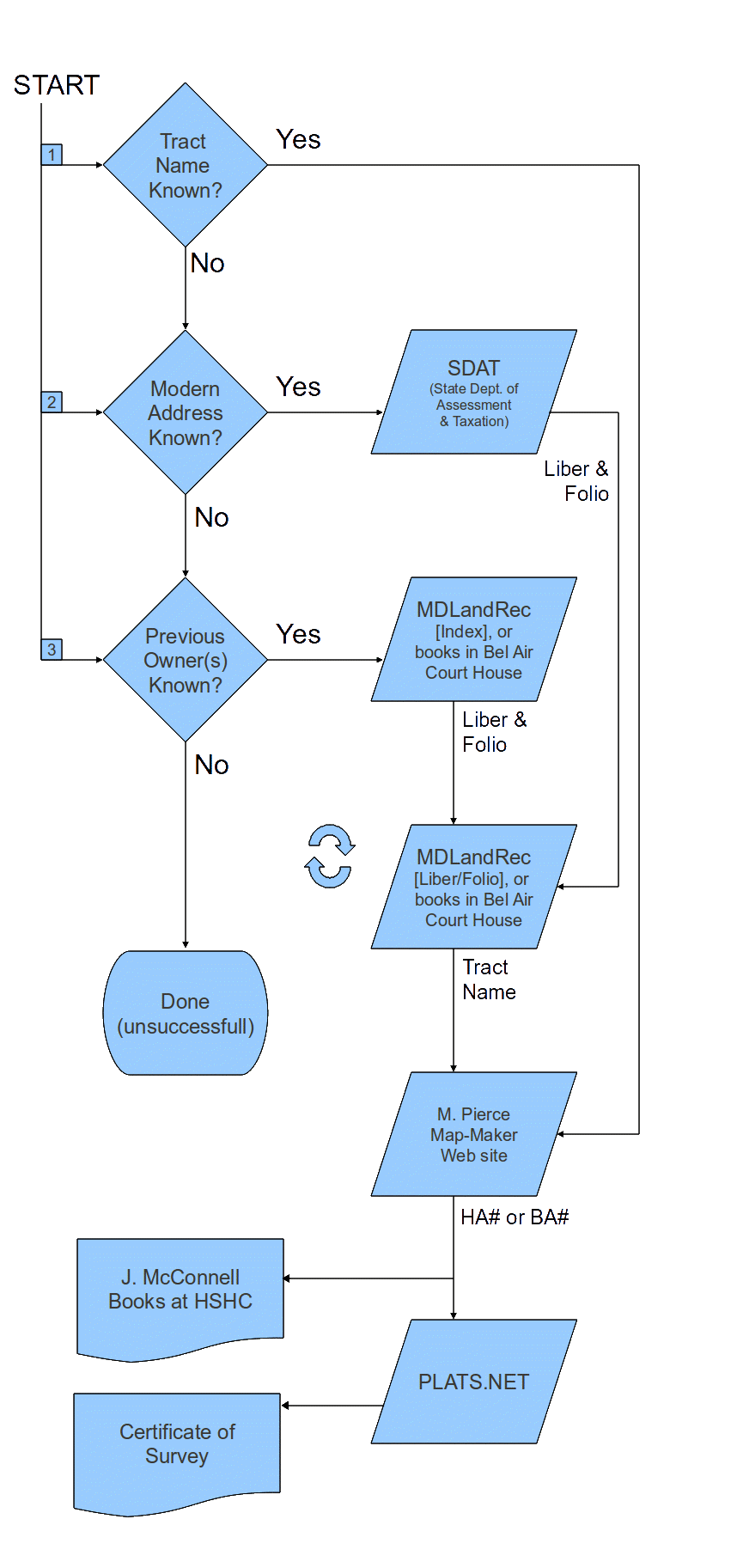 |
As indicted by the rotating arrows next to “MDLandRec [Liber/Folio]”, there may be several interations of going back through the Liber & Folio references to find a ‘Tract Name’. Although a few modern deeds still contain these references, generally speaking you have to get back to about the 1870s to find these references. Be diligent … some property has changed ownership very few times and other property has changed ownership many, many times.
The most significant issue you will have problem resolving is if the property passed from parent to child by a will and the child did not register the deed at the court house. This is particularly problematic is the child was a married daughter. And now that the Register of Wills office has moved from the court house to Office Street, all the books, except the indexes, have been shipped to Annapolis making research much more time consuming [hopefully these will be digitized some time in the future].
The Genealogical Society presentations below require a PDF Reader. Either of the following free software programs should serve you in the event your computer does not have such a program already installed:
Fox-It PDF Reader, or
Adobe Acrobat Reader.
Go to the MDLandRec web page here. If surveyed pre-1774, you will need access to both Baltimore County information.
You can view the (modified) Genealogical Society’s MDLandRec presentation here.
Go to the PLATS.NET web page here.
You can view the (modified) Genealogical Society’s PLATS.NET presentation here.
Go to SDAT Real Property Search here. This is the (Maryland) State Department of Assessments and Taxation web page. If you only know the current street address, this will be your starting point. If you need some assistance with this web page, please see the (modified) Genealogical Society’s presentation on using SDAT here.
Happy hunting!